Aircraft weather radar is one of the most important tools for flight crew situational awareness when operating near areas of hazardous weather. It helps pilots identify areas of precipitation, thunderstorms, and regions that may be associated with turbulence, hail, and convective activity.
However, it should not be understood as a “perfect view” of the weather. Airborne weather radar has important limitations: it does not directly detect every atmospheric hazard, and it relies mainly on signal returns from precipitation particles. That is why proper interpretation is essential for flight safety.
The radar is hidden in the nose of the aircraft
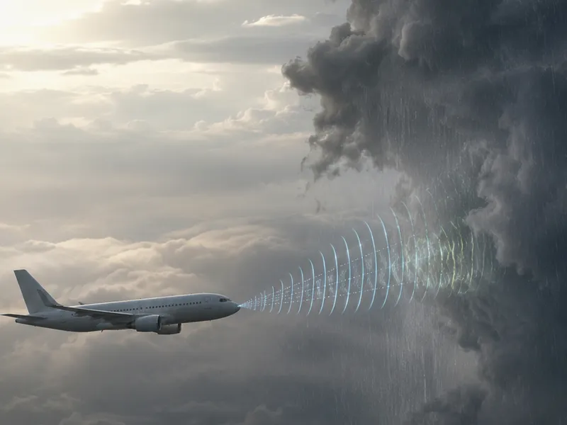
On many commercial aircraft, the weather radar antenna is installed in the forward section of the airplane, behind the radome. The radome is the rounded structure that forms the aircraft nose. It protects the antenna while allowing radar radio waves to pass through with minimal interference.
This area has to serve several purposes at the same time: it must preserve aerodynamic shape, protect internal equipment, and allow radar energy to be transmitted and received effectively.
So, when we look at the nose of a commercial aircraft, we are not only seeing an aerodynamic shape. On many aircraft, that area also houses an essential component used to detect weather conditions ahead of the airplane.
The basic principle: transmit and receive
Weather radar works on the echo principle. The antenna sends electromagnetic energy pulses forward from the aircraft. When those pulses encounter weather targets capable of reflecting part of that energy, a portion of the signal returns to the antenna.
The system measures how long the signal took to travel to the target and return. From that, it calculates distance. The antenna direction helps determine where the echo is located relative to the aircraft.
In simple terms, the weather radar “asks” what is ahead by transmitting energy, then interprets the echoes that come back. Those echoes are processed and displayed to the flight crew.
Weather radar mainly detects precipitation
A key point is that weather radar does not detect clouds the same way our eyes see a cloud. It primarily detects energy reflected by precipitation particles, especially liquid or wet particles.
The FAA explains that airborne or ground-based weather radar will normally reflect areas of moderate to heavy precipitation. The FAA also clearly states that radar does not detect turbulence directly. The relationship is indirect: higher radar reflectivity is closely associated with areas of high liquid water content in a storm, and turbulence frequency and severity generally increase with reflectivity.
This means a red area on the radar is not simply a “red cloud.” It represents a strong return, usually associated with intense precipitation, which may indicate a hazardous weather area.
Weather radar does not show weather like a camera. It interprets returned echoes, mainly those associated with precipitation.
What do the colors on the display mean?
On weather radar displays, echoes are commonly shown in colors. The exact display logic may vary depending on the radar manufacturer and aircraft configuration, but the general purpose is to represent different levels of return intensity.
Weaker returns are often shown in green, moderate returns in yellow, and stronger returns in red or magenta, depending on the system. These colors help the crew quickly assess where precipitation is more concentrated and where the associated hazard may be greater.
It is important to remember that these colors do not directly show “pure turbulence.” They show reflectivity, mainly associated with precipitation. Turbulence may be associated with these areas, but conventional airborne weather radar is not a direct clear-air turbulence sensor.
Why are thunderstorms so important in aviation?
Convective thunderstorms can combine several hazards for flight operations: heavy rain, severe turbulence, hail, lightning, icing, strong updrafts and downdrafts, and wind shear. The FAA’s thunderstorm advisory circular emphasizes that thunderstorms represent significant aviation hazards and should be avoided.
For that reason, airborne weather radar should not be viewed as a tool for “punching through” storms. It is a detection, interpretation, and avoidance tool. Its most important operational role is to help the crew identify hazardous areas and plan a safer route around adverse weather.
Amazon Recommended Products
AVIATION PICKS



The role of tilt: aiming the antenna
One of the most important controls on conventional weather radar is tilt, which adjusts the vertical angle of the radar antenna. It allows the crew to aim the radar beam upward or downward relative to the aircraft flight path.
This matters because the radar does not see the entire atmosphere at once. It transmits a beam with a certain width and direction. Depending on the aircraft altitude, selected display range, and storm location, the antenna may be pointed above, below, or directly at the most significant part of the weather cell.
Airbus technical guidance on weather radar use explains that antenna tilt should be adapted to the selected navigation display range, aircraft altitude, and expected weather conditions. It also notes that tilt must be adjusted as the flight progresses.
Why proper radar use matters
A weather radar can display a lot of information, but that information must be interpreted correctly. Poor tilt, range, or gain management can cause the crew to underestimate or misread an area of adverse weather.
Another important limitation is attenuation, also known as “shadowing.” This happens when an area of intense precipitation absorbs or reflects a significant amount of radar energy, reducing the radar’s ability to see what lies behind it.
Airbus describes this limitation as shadowing or attenuation and explains that the radar display depends on signal returns: the more intense the return, the more radar energy may be lost before reaching areas beyond that point.
Therefore, an apparently “clear” area behind a very strong echo does not always mean the area is truly free of hazard. It may be masked by signal attenuation.
Weather radar does not see everything
One of the most important concepts for the general public is that weather radar has limitations. It does not directly detect dry clouds, fog, wind without precipitation, isolated lightning, or clear-air turbulence.
The FAA clearly states that weather radar normally reflects moderate to heavy precipitation, but does not directly detect turbulence.
In addition, dry frozen particles may reflect less radar energy than rain or wet hail. The National Weather Service explains that aircraft radars do not see frozen precipitation as well as wet precipitation; rain, wet hail, and wet snow are much more reflective than dry hail, ice crystals, or dry snow.
This helps explain why a storm may still be dangerous even when some regions do not appear as intense on the radar display.
Weather radar is not a complete weather solution
Although weather radar helps the crew make route decisions around adverse weather, it does not replace preflight weather planning, air traffic information, weather charts, pilot reports, satellite imagery, datalink weather, or airline operating procedures.
It is an onboard tool for visualizing and interpreting weather conditions ahead of the aircraft, especially those associated with precipitation. In flight, pilots combine radar information with training, procedures, experience, and other sources of weather data.
Avoidance is the goal
The most important operational message is simple: weather radar helps crews avoid hazardous weather areas, not penetrate them without judgment. Strong thunderstorms may contain hazards that do not appear perfectly on the display, and areas near convective cells can also be dangerous.
FAA thunderstorm publications advise pilots to avoid severe weather and emphasize that thunderstorm cells may be associated with turbulence, hail, updrafts, downdrafts, and wind shear.
So, when an aircraft deviates around a storm, that is not “fear of clouds.” It is risk management. The flight crew uses radar to identify the highest-threat areas and select a safer path.
Aircraft weather radar is an essential operational safety tool, but it must be understood correctly. It does not show weather like a camera, and it does not directly detect every atmospheric hazard.
It works by transmitting energy pulses and interpreting the echoes that return, mainly from precipitation. The colors on the display indicate return intensity, not an absolute guarantee of where hazards do or do not exist.
For that reason, weather radar should be used as an interpretation and avoidance tool. It helps the crew recognize areas of heavy rain, thunderstorms, and possible regions associated with turbulence and hail, but its limitations require technical knowledge, proper adjustment, and careful operational decision-making.
References
Federal Aviation Administration — Aeronautical Information Manual, Chapter 7, Safety of Flight. FAA information stating that weather radar reflects areas of moderate to heavy precipitation and does not directly detect turbulence.
Federal Aviation Administration — Advisory Circular AC 00-24C, Thunderstorms. FAA document on thunderstorm hazards to aviation and accident prevention.
Federal Aviation Administration — Thunderstorms: Don’t Flirt... Skirt ’Em. FAA Safety Team material on weather radar limitations and thunderstorm hazards.
Airbus Safety First / SKYbrary — Optimum Use of the Weather Radar. Technical material on proper airborne weather radar use, tilt setting, and operational interpretation.
Airbus Safety First — Optimum use of weather radar. Material discussing airborne weather radar limitations, including attenuation and shadowing.
National Weather Service — Airborne Weather Radar Limitations. Technical material explaining limitations in detecting dry frozen precipitation compared with wet precipitation.